W is for Western Australia. It occupies the entire western third of and is the largest state in Australia, and the second largest national region in the world. It measures 1500 kilometres from west to east and 2400 kilometres from north to south and has a coastline of 20 781 kilometres. A large part of the state is arid desert and the population is concentrated in the south west. Below is a map of Australia to try and give some perspective on the size of the country (France, Germany, Italy, Portugal and Ecuador would roughly fit into Western Australia).

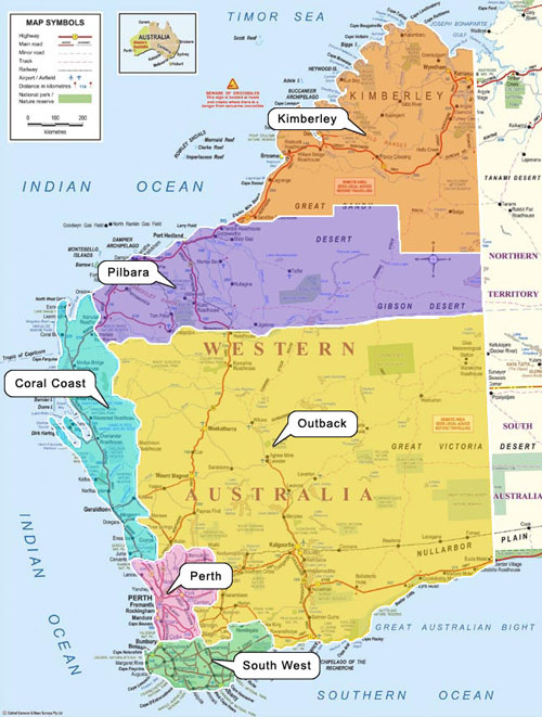
Some of the different regions in Western Australia
We have visited quite a few places mostly along the coast of WA. This post is taking you on a (shortened) virtual road trip through the parts of WA we’ve been to. Some of the photos will be familiar as I’ve used them before. Starting in Perth we’re heading south west to the winery region around Margaret River. The area is also famous for its forests, surfing beaches and caves.


From there we head further south east to Denmark, Albany and Bremer Bay. Along the way we’re making a short detour via the Porongorup mountains and the Stirling Ranges.


From Bremer Bay we head further east along the coast to Esperance – which is 800 kilometres from Perth via the most direct route – and past Esperance to Cape le Grande National Park, and also hopping over to Woody Island for a day trip. Woody Island is one of 105 islands that make up the Recherche Archipelago south of Esperance.


")

From Esperance we’ll head back towards Perth driving through some vastly beautiful wheat belt (farming) country past Wave Rock, stopping at a working farm to see a Kelpie (an Australian sheep dog) at work and detouring via Kalgoorlie – a gold mining town which is home to the Superpit – Australia’s largest open cut gold mine.


Back in Perth we’ll go to Rottnest Island (about 40 minutes away by ferry) for a day trip.
")


Then we’ll head north to the Coral coast, Ningaloo Reef and Coral Bay (about 1200 kilometres), stopping at the lookout to Shark Bay and Monkey Mia on the way. In Coral Bay we can snorkel and go on different glass bottom boat tours to see turtles and manta rays.


From Coral Bay we’ll head another 1200 kilometres away north east up to Broome in the Kimberley region, known for its beautiful contrasting colours and red (pindan) sand. In Broome we’ll swim at Cable Beach, do a sunset camel ride and take a helicopter trip up to Willie Creek Pearl Farm.


North of Broome and the rest of the Kimberley is one area (of WA) our family hasn’t explored yet and are planning to do as soon as we’re able to. From Broome our virtual road trip will head back to Perth which will be a two day trip of driving 12 hours each day. Towards the end of the first day we’ll pass Karijini National Park and the Hamersley Ranges, another spot to visit on a different trip. There are beautiful gorges and rock pools there.
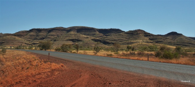
Edge of the Hamersley Ranges, Karijini National Park, north west Australia
Back in Perth we’ll stop to visit a local beach, see the sights and sounds and go to the city.


Baie mooi. Selfs ek sal dit waag op die Skywalk (ek ly vreeeeeslik aan hoogtevrees) om daardie pragtige uitsig te sien.
LikeLiked by 1 person
Dis ‘n ongelooflike uitsig so ek sal jou eerder nie vertel van die leer waarmee jy moet opklim om daarbo uit te kom nie!
LikeLiked by 1 person
Ok, skrap daai idee. My knieë sal dit nie maak nie. 😀
LikeLiked by 1 person
Ai tog, jammer! Ek is self nie te vol selfvertroue wanneer ek by daai leer opklim nie! Ek kan nie afkyk nie maar as ek eers bo is voel ek heel veilig.
LikeLiked by 1 person
Wel, tenminste lyk dit asof die brug baie stewig aanmekaar gesit is. Ek het al veel erger gesien.
LikeLiked by 1 person
Ja dis ‘n baie stewige struktuur.
LikeLiked by 1 person
WoW!! That’s some trip! Thanks! 😉 I think you have a calendar or two there… great photos… great place! ( I dream of going to the Kimberley one day… with my metal detector in tow! 😀 )
LikeLiked by 1 person
🙂 thank you!
LikeLike
Again an awesome post on West Australia. I think one can really fall in love with that side of Australia. It is so beautiful . Your photos are breathtaking! Thanks for all this information.
LikeLiked by 1 person
Thank you, I’m glad you enjoyed the “road trip”.
LikeLiked by 1 person
Pingback: Blogging from A-Z: Letter W – I scrap 2
Thanks so much for this virtual tour. Such a huge area to explore. I love the first map, with so many countries fitting into this vast land.
LikeLiked by 1 person
The size of the country and the distances between places always amaze me!
LikeLiked by 1 person
Sjoe dis pragtige plekke en jy bied dit so interessant aan met die mooiste foto’s!
LikeLiked by 1 person
Baie dankie, dis regtig fotogeniese plekke.
LikeLiked by 1 person
Giving people an idea of the size of Aussie is good.
A fantastic state I spent many months traveling in WA.
I could have spent years and still be experiencing amazing things.
I enjoyed the photos you did well with your coverage.
And I am sure you have much more you could show us. _/\_
LikeLiked by 1 person
Thank you! We’ve lived here for 11 years now and also feel like we have lots still to see and yes, I tried to limit myself to one or two photos per area otherwise I’d overload everyone. Thanks for stopping by.
LikeLike
One can never see it all, only saver and appreciate what is available. There are wonderful things in every garden. _/\_
LikeLiked by 1 person
‘n Lekker toer deur W A, waarvan ek net ‘n klein bietjie gesien het.
LikeLike
The pictures you provided are just stunning! Great post, Christina!
LikeLiked by 1 person